Urban Access to Green Space
This is a case study of access to green space in the adjacent communities of Santa Ana and Irvine, CA. Despite being geographic neighbors, Santa Ana has drastically less access to green space than Irvine. Spatial analysis reveals that Irvine's land use is 28.51% residential and 7.2% park space, while Santa Ana is 36.53% residential but has only 2.1% park space.
In Santa Ana, 26.52% of the residential area lacks easy access to green spaces. While this percentage is even higher in Irvine-30.5%, the raw percentage does not account for differences in population density. Indeed, when we consider each city's ratio of residential area to park area, we find that Santa Ana's park spaces need to accommodate more than 4 times the residential region as Irvine's park spaces.
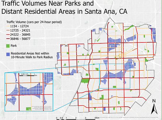
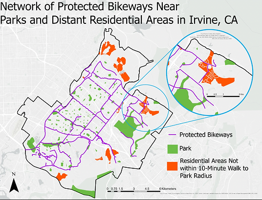
I took this analysis one step further by looking at the safety of access to green spaces in each city. In Irvine, we observe a network of protected bike paths that offers safe access to green spaces. For residential areas that are not within a 10-minute walk of a park, parks are accessible through safe bike paths. In contrast, the city of Santa Ana does not even offer a bikeway vector file. They do offer, however, data on traffic intensity in the city. This data reveals that many residents would have to cross high-traffic streets in order to access green space. Other communities, like the central area displayed in the popout, are completely boxed in by highly-trafficked streets with no internal green space access.